4-8 HoursPark entrance fee required.
Bicycling at Mount Rainier National Park
Mount Rainier National Park
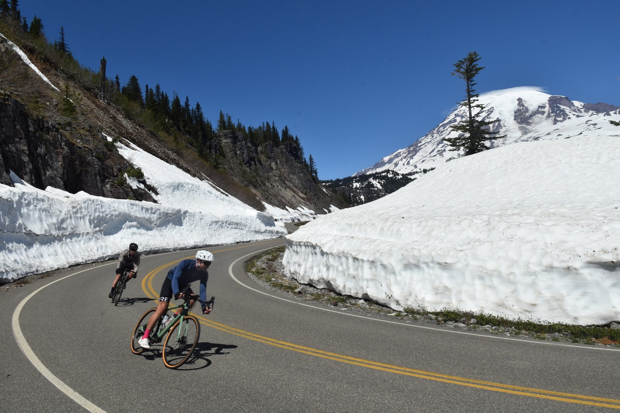
Bicycling at Mount Rainier National Park is both scenic and challenging. Bicycles are allowed on park roads but they are not permitted on any hiking trails.
At Mount Rainier, bicycling is both challenging and scenic. Bicycles are allowed on park roads but they are not permitted on any hiking trails and the park does not have any designated bike trails. Be aware that the park may temporarily close any road to bicycle use. Signs will mark closed roads and bicyclists can check current road status when planning a trip. Availability of bicycling equipment in or near the park is very limited and bicyclists should be prepared to make repairs on their own. Most of the park does NOT have cell coverage. For your safety, wear a helmet. Park roads are steep, narrow, winding and have unpaved shoulders. There are several significant elevation gains and losses. Bicyclists are advised to maintain safe speeds on downhill sections. While in the park, bicyclists are required to ride single file. Bicyclists may ride two abreast only on Westside Road, where vehicles are not allowed. However, please be aware of hikers also using those routes and yield to hikers. Please review additional bicycling safety guidelines and regulations for Mount Rainier National Park. Riding the Roads Nisqually Entrance - Paradise From the Nisqually Entrance, in the southwest corner of the park, it is 19 miles one-way with an elevation gain of 3,400 feet to Paradise. Note that this road can have heavy summer traffic, including RVs. Bicyclists must ride single file. NE Entrance - Sunrise From the northeast park boundary on SR410, it is 20 miles with an elevation gain of 3,650 feet to Sunrise. Note that this road can have heavy summer traffic, including RVs. Bicyclists must ride single file. Carbon River Trail (former road) - CLOSED There is NO public access to Carbon River & Mowich Lake from SR 165 due to the closure of the SR165/Fairfax Bridge outside of the park. The bridge is closed to pedestrians, bicycles and vehicles and there is no alternate route. Mowich Lake Road The Mowich Lake Road is also in the northwest corner of the park at the end of Highway 165. Starting from the Paul Peak trailhead near the park border, this five-mile dirt road leads to a beautiful subalpine lake with an elevation gain of approximately 1,400 feet. Please note that this dirt road often has rough conditions with large potholes and is popular with 4-wheel drive vehicles. Westside Road** The Westside Road is one mile from the Nisqually Entrance, in the southwest corner of the park. The first three miles of the road are open to motor vehicles as well as bicycles. There is a small parking area at Dry Creek at the end of this three-mile section and many mountain bikers choose to leave their cars at this point. From Dry Creek, the road climbs to Round Pass, descends into the South Puyallup River Valley, then climbs to Klapatche Point, where the road terminates. From Dry Creek to Klapatche Pass, the road is 9.25 miles long with an elevation change of approximately 2,100 feet. Please note that due to danger from rock fall, vehicles must park south of the barricade at Dry Creek. Hikers and bicyclists should travel through the area with caution and avoid lingering in the hazard zone. **Only E-bikes possessing a motor of less than 750 watts (1 h.p) on which the motor only assists with pedal propulsion are permitted.
Tags
BikingMountainsScenic ViewsRoads, Routes and Highwaysmount rainierbicyclingbike ridingbikingbiking safetyroad bikingMountain BikingCarbon River Trailcarbon river roadWestside Road
Visitor Photos
No visitor photos yet
Details
Duration
4-8 Hours
Duration Details
Bicycling most roads can take several hours or the majority of the day depending on route.
Fees
Park entrance fee required.
Fees Apply
Yes
Seasons
Summer
Time of Day
Day
Accessibility
Most park roads are paved, but are narrow, steep, and winding with no shoulders. Many of the roads have significant elevation gains. Westside Road, Carbon River Trail (former road), and Mowich Lake Road are gravel, sometimes broken by rockier sections with washouts or large potholes.
Pets
No — Pets are allowed on roads open for vehicles, but are not allowed on Westside Road or Carbon River Trail.
Reservations
No
Age Info
Suitable for all ages.
Location
Park-wide Roads