1-120 MinutesFee applies
Contemplate Your Place in the Landscape At The Big Map
Rainbow Bridge National Monument
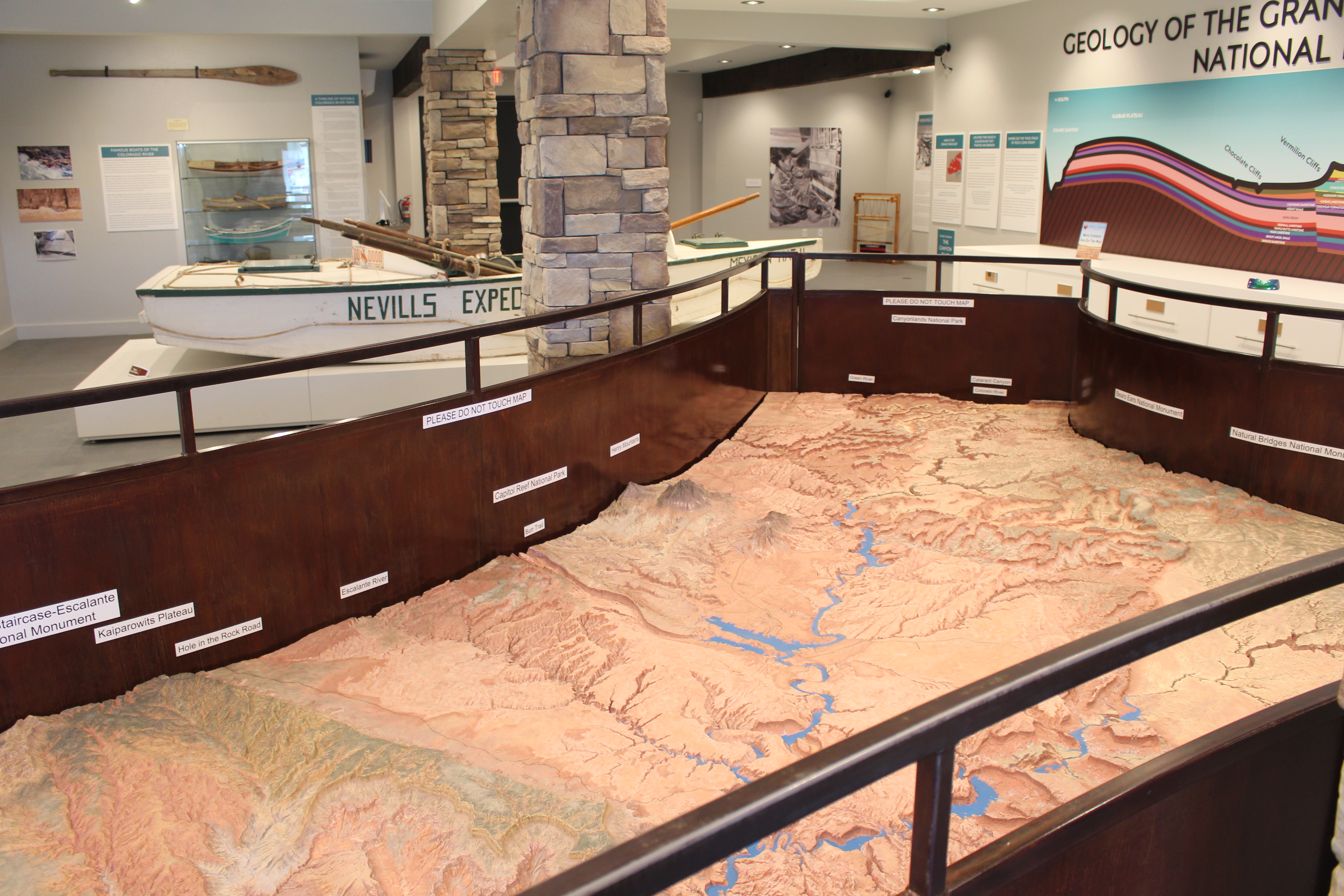
The Glen Canyon and Surrounding Area Relief Map sits in a place of honor at the Powell Museum & Archives next to Glen Canyon Conservancy's Flagship office. Use it to help plan your Glen Canyon adventure, or pretend you are in space looking down at the landscape. Whoa.
During the construction of Glen Canyon Dam, The U.S. Bureau of Reclamation commissioned a scale model relief map of what would be Lake Powell and the surrounding area. Model map builder Robert Miller used information from topographic maps and overflights of the area to construct the model in his basement. It took over a year to complete. He cut the map into seven pieces to be transported to the opening of the Glen Canyon Visitor Center, later renamed after Arizona senator and water use proponent Carl Hayden. This terrain relief model of the Glen Canyon National Recreation Area and vicinity can only be described as precisely accurate. The topography shown was based on both topographic maps and aerial photographs. Everything on the map actually exists just as it appears to, considering the vertical scale of the model. When it was installed at the visitor center at Glen Canyon Dam, is was oriented to real life. You could use it for wayfinding. In 2017, during the installation of new exhibits at Carl Hayden Visitor Center, the relief map was cut into the original seven pieces and removed from the building. Two years later, park partners Glen Canyon Conservancy retrieved the pieces and reassembled the map at their Flagship office and retail store for the public to once again enjoy and plan trips. In mid-2023, renovations at the Powell Museum & Archives were complete, so the map has a forever home amongst relevant exhibits. Over 55 years after its construction, aside from a few new roads, the map still accurately depicts the landscape of and around Glen Canyon National Recreation Area.
Tags
Museum ExhibitsSculptureCanyons and CanyonlandsDamsGeologyLakesMountainsRiver and RiparianRock Landscapes and FeaturesArchesButtesScenic ViewsTrailsBridgesRoads, Routes and HighwaysGlen Canyon National Recreation Areaglen canyon conservancyBureau of ReclamationRelief maphistoric mapLake Powelltrip planningcontemplation
Visitor Photos
No visitor photos yet
Details
Duration
1-120 Minutes
Duration Details
Take a second glance, take an afternoon. Our friends welcome visitors to take their time (while the building is open) and see what they can find on the map.
Fees
Admission to the museum is as follows: GENERAL: $12 MILITARY / SENIOR 62+: $10 STUDENTS 10-17: $5 CHILDREN 0-9: FREE LOCAL RESIDENTS: FREE TOUR GROUPS (WITH ADVANCE NOTICE): $5 PER PERSON
Fees Apply
Yes
Seasons
Winter, Spring, Summer, Fall
Time of Day
Day
Accessibility
The relief map is about three feet high, 12 feet long. A railing surrounds it, leaving room for wheelchair approach. The exhibits in the building are on a flat floor, and a ramp is available to make way to the gift shop. Service animals are permitted in the building.
Pets
No
Reservations
No
Age Info
All ages can view the map, but please do not touch or try to get on it.
Location
Glen Canyon outside of Glen Canyon